The Caithness Crofts
Thura was given as the home of David Oal at his marriage to Eliza Durran and it has to be assumed that this was the family home, especially since my fellow researcher Iain Old discovered that there was a person with the surname Honeyman living at Thura. He says -
"Firstly, you many remember that I mentioned that a George Taylor and his wife Euphy Honnyman were living at Thura in 1771 and that I proposed that Honyman Oal may have been named after Euphy, who may have been the daughter of "Sir" William Honeyman. On the Scotland's Places website I found horse tax records for 1797-8 and they include a "Doctor Taylor of Thura" who owns six horses. He is presumably a member of the same Taylor family and this backs up the theory that the Taylors were the tenants or owners of Thura, rather than merely workers.
There is also a "Donald Finlayson of Occorn" with four horses."
The William Honeyman here is Lord Armadale who removed people from his lands in favour of sheep. He may have had an influence in this area and Honeyman may have been the "victim" of this policy. Alternatively he may just have left to seek his fortune elsewhere but we have to be thankful that he did otherwise the family would have taken a different course.
The censuses give some indication of who was living in the different communities but they only start in 1841. However we can see from them that several families lived in each farm in the area. Thura in 1841 doesn't have any Oals but there are five households, one of which houses a "manager", one a "farmer", one an "agricultural labourer", one a cryptic "M." and one a collection of young male agriculural labourers with one 40 year old female agricultural labourer! As such, we don't know the status of the Oals in Thura or in Auchorn.
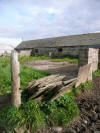
This photo shows part of Thura as it is now. Old maps suggest that the building on the left has been there a long time but the one on the right shows signs of more modern construction techniques. The one on the left may have been thatched or turfed over flagstones originally.
In that 1841 census there are three unmarried female Oals living in next-door Whitegar, Catherine (55), Ellen (35) and Elisabeth (30), Catherine being listed as Independant and the other two not noted as anything. They are Honeyman's sisters and it begs the question as to why none of them married. Were they unattractive or were they all disabled in some way as a result of some childhood disease hitting the household? It's unlikely that they were too poor to marry as nearly everyone was poor in that area at that time. Looks were a secondary consideration in those days to being good healthy breeding stock so there's a suggestion that maybe they were sickly creatures. As with other mysteries, we'll never know at this distance in time.
Someone was telling wee white lies though. In the 1841 census adult ages were rounded down to the nearest five years but Ellen and Elisabeth rounded theirs down by 18 years! Catherine's 59 was correctly recorded as 55. In the 1851 census Helen and Elizabeth (new spellings) were 50 and 46 against their real ages of 63 and 58 so they've corrected it a bit but their big sister who was now 69 has only admitted to 60. Ten years later Helen and Elizabeth have admitted to a more realistic 72 and 64. Their real ages are known from their birth records of course.
Whitegar is still inhabited today but the road into it is more suited to tractors than cars.
On the other side of Thura is Auchorn, a place of many spellings. It is variously Acorn, Aukhorn, Occorn and so on and even mis-transcribed as Buckhorn, all making it difficult to find by computer searches. There is even another farm of the same name less than 5 miles to the east to confuse matters. We do know this was the birthplace of David Oal, or at least Oucorn was. I was able to walk round the farm buildings when I visited the area as the place was unoccupied and up for sale. Old maps show that some parts are older than others and this is supported by the building materials used. Despite obvious changes over the years I know I have trodden the same ground as my ancestors from the 1740s and probably before. These are some of the photos I took on the site.
These buildings have obviously undergone periodic change over the years but some features such as the walls and flagstone floors will have remained. The buildings shown here are the older ones as indicated on the old maps. There are some evidently newer additions on site as well, breeze-block being one obvious indicator.
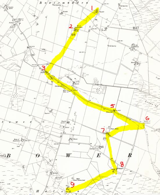
Honeyman's mother Elizabeth Durran is from Dophtkemp or Toftkemp and although this has been difficult to locate, given no references on any map, the sequence of entries in the 1841 census suggests that this is actually Auchorn under a different name. The sequence of named places is as shown below with Toftkemp listed between locations 3 and 5. It seems obvious to me that 4 is Auchorn under a different name especially since Auchorn isn't mentioned itself. The original map can be referenced here and Toftkemp is between Bower and the first reference to Thura. Thura is again mentioned after Greeniquoy.

It has been suggested that Toftkemp could actually be another local farm now named Campster as Toft- and -ster both mean farm and kemp and camp could be different spellings of the same place. However, Campster is out of place, being a couple of miles south-west of where the aforementioned census location is presumed to be. I'd have left it at that had the Bremners who lived in Toftkemp in 1841 not moved to Campster in the 1851 census. Are Toftkemp and Campster the same place or have the Bremners moved and taken a slightly modified name with them? It's difficult to say and it doesn't really matter much anyway.
All Internet searches for Thura or Toftkemp seem to lead to this document which doesn't really help locate Toftkemp except an initial statement that Toftkemp and Thura are in the parish of Bower.
The last placename to locate is The Bog, as referred to in Honeyman's birth record. It may be an actual farm or just a boggy area. The name doesn't appear on any map I've yet seen.
My wife Sandra's Mackay tree also has a branch in the area. Her father's mother's father was George Bruce who was born in Watten before moving to the Clyde to work in the shipbuilding industry. He was the illigitimate son of a boatbuilder from Wick but his mother was from a crofting family, the Mackadies (with various alternative spellings). Again, I have visited the very buildings they lived in, the crofts of South Dunn, some five miles south-west of the Bower area of the Oals, although they are more-or-less all ruined now with some retained as animal shelters. These photos were taken on-site. There should be one featuring a barn owl as it swooped over my head and out of the door but it was too fast for the camera.
The first shows the sort of bleak landscape the crofts lie in and one of the Lanergill crofts the Mackadies later moved to. Sheep farming definitely looks like the most suitable option for the terrain. The second shows the actual buildings I believe the Mackadies lived in although they do look to have been built at different times. The third and fourth show the more modern building and it can be seen that they had the local flagstones on the roof with presumably serious wooden beams supporting them and turf on the top to insulate. The fifth shows the construction of the thick walls and the sixth shows the current use as an animal shelter with flagstones acting as dividers. Flagstones are even used as fences in this area.
Peat was and still is cut, dried and used as fuel in this area.
We can trace the Mackadie line back into the 1700s and there's no indication that there would have been much movement before that. It's interesting to suggest that Sandra's and my ancestors would have met and talked to each other at the local farmer's markets way back in the 1700s and before.
I mentioner earlier that Honeyman's sisters never married. In the 1861 census for the South Dunn area there are some amazing discrepancies in ages between couples (68/61, 88/71, 69/50 and 44/60) suggesting that maybe there wasn't a huge range of choice of partner in the widespread communities, which makes it even more surprising that the Oal girls remained single.


